We left Ft Madison around 9:30AM and headed south with the goal of making it to either Quincy, Hannibal, or Louisiana, MO. They're listed in order of increasing distance and the farther we can get the better. We decided last night that we need to step up the pace and cover more miles per day or we risk falling behind in being able to fit the trip into the allotted time frame. The realization of our lagging behind was stirred during a conversation with son Matthew. He offered to run some quick calculations for me and and informed me that there is no margin left in the schedule. If we don't get a few 100 mile days under our belts we'll remain tight on time for the rest of the trip. Well right now I'm happy to report we are in fact in Louisiana so we achieved our goal for today. Tomorrow we'll need to make it to Alton, IL, just north of St Louis, to put us back in good shape and rebuild our two days of slack for unexpected events. I also took a final check of the maps for tomorrow and was pleasantly surprised to find we only have two dams to get through. I had initially thought there were three dams, numbered 23, 24, and 25 to be negotiated, but it turns out there is no dam #23. I'm not sure what happened to it and maybe I'll investigate it sometime but not now.
We couldn't have had a better day for making good progress on our trip. The weather was excellent and the water calm. The only rough water conditions were experienced behind the big tows and I'm amazed at how much, or should I say, how long they can churn up the water. Immediately behind the tow is a violent thrust of water that is cool looking but doesn't much affect a boater like me unless I'd stupidly get entangled with it. The real and more enduring effect is the rolling and pitching experienced for 3-4 miles behind them. It can instantly turn what was smooth water into a busy Fourth of July weekend.
 |
| As we departed Ft Madison I quickly noticed this interesting phenomenon. The water, at 82 degrees, was warmer than the air causing this lensing affect that makes the distant shoreline appear vertically elongated. The white objects are houses. |
The locks at Keokuk, IA were the first where we saw a really significant drop in water. We dropped roughly 25 feet from the upstream to downstream side. Mary got a bit twitchy we we dropped down into the lock chamber as the water was drained out.
 |
| We're down about 25 feet inside the Keokuk lock chamber. See the water line above us where we started . The Keokuk dam is privately owned to generate electricity so there is economic motivation to impound as much water upstream as possible. |
 |
| In a lock chamber as deep as the Keokuk dam a device called a bollard is used to tie off your boat. See my rope draped over the round post. The post rides up and down with the water for the obvious reason of preventing someone from securely tying their boat to the wall, and then with the water dropping out from under them, they literally "hang" their boat. |
 |
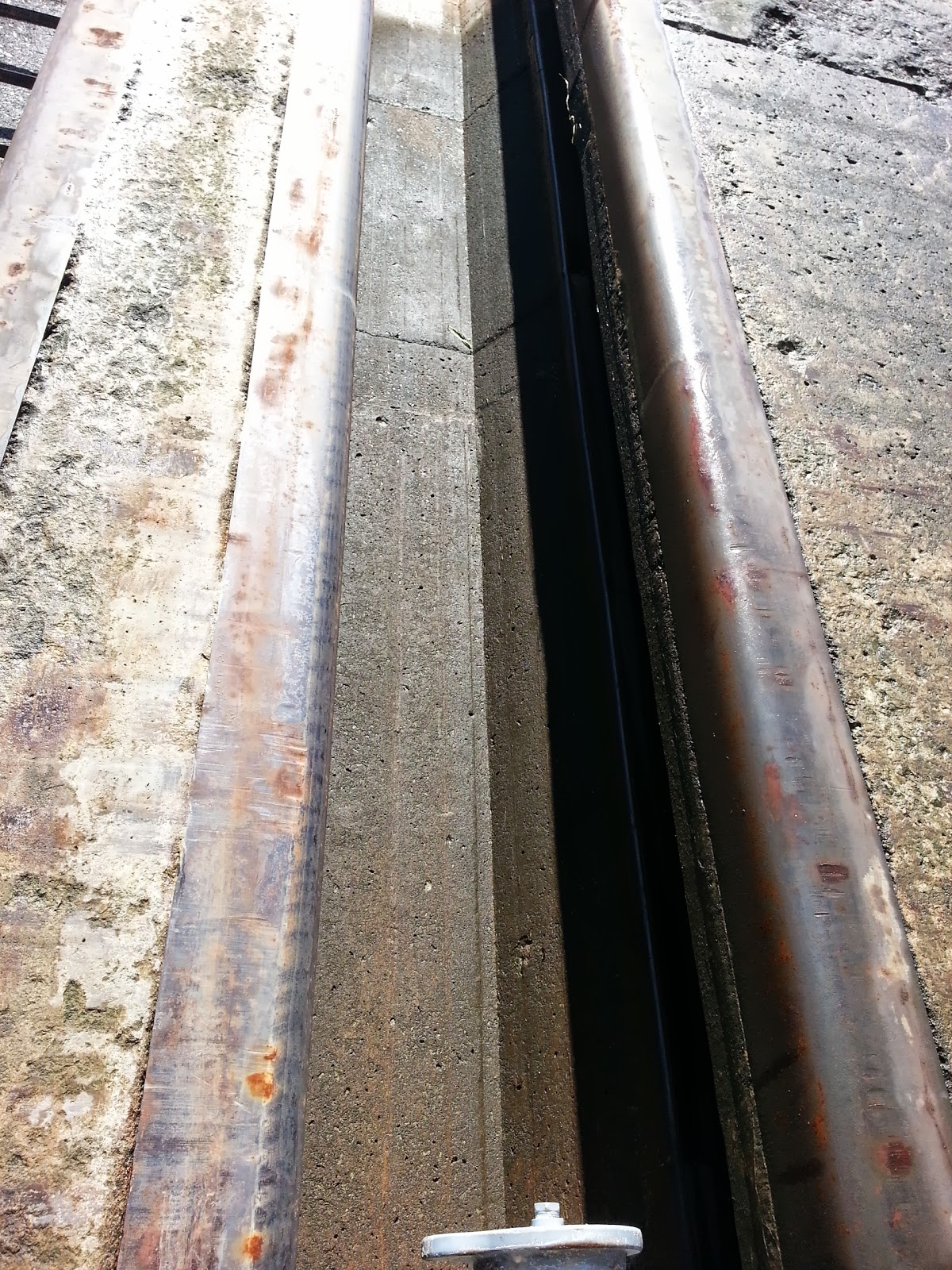
This is the track embedded into the concrete wall on
which the the bollard moves up and down |
 |
This is the bigger view of the bollard.
It is a big floating drum on a track and is entrapped in the concrete wall. |
 |
| When you go through a lock you are often times an object of someone's touring activities. This time I took a picture back to get even. I've chatted with folks like these on a few occasions and a question I've been asked more than once is, how much do you have to pay do get through here? The answer is of course nothing. |
 |
| We passed Hannibal and discovered that activities and facilities were not up to normal operation due to the flooding. I talked to an employee of the city and was told that only yesterday did they lift the flood gate out of the dike near their marina. We didn't spend any time here and have not regrets because it is a place easily visited on another occasion. |
 |
| I like this picture because it fools you. It looks like the Blue Fin is sitting restfully in the glassy waters. It was 3 o'clock in the afternoon and we were cruising at 25 MPH when this pic was taken. |
 |
| Lock 22 was our last lock-through of the day and whew! Were we surprised when the gates opened and this barge was aimed straight at us nearly blocking our exit? We were directed to sneak out through that small opening to the left which put us right out in front of the main dam and resulted in us getting swished downstream at a brisk pace. |
 |
| A view from our motel room in Louisiana, MO. Across the river near that small lighthouse shaped tower is the marina where the Blue Fin is resting for the night. The bridge is about 1/2 mile long and I couldn't convince Mary to bicycle across it. The motel manager picked us up instead. |
 |
Two 10 foot lanes, so so guard rails, 60 feet in the air, and large truck traffic.What's the problem with bicycling on this bridge? |